Maricopa City Council was presented with a less-than-favorable floodplain update, evidence of likely delayed development.[quote_right]“Right now, we are kind of sunk at this point.” – Public Works Director Bill Fay[/quote_right]
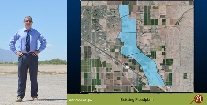
The City of Maricopa, in conjunction with several developers, was planning to construct a channel that would dramatically shrink the city’s four major flood zones. That would allow for development in areas currently residing in the floodplain.
But those plans for the North Santa Cruz Wash Capital Improvement Project have hit a wall, according to Maricopa Public Works Director Bill Fay.
Citing adjusted flow-rate assessments by the Army Corps of Engineers, Fay indicated their current timeline for development, which was slated for sometime in 2018, must now be reconsidered.
In the early fall of 2016, the city completed a tenable assessment of flow at around 7,500 cubic feet per second (cfs).
As Fay put it, they “were right there at the gate about to go into hard design.”
The Corps, however, conducted a larger, regional floodplain study, and at a conference “verbally expressed” an inflow assessment in excess of 18,000 cfs, almost tripling the assessment of the city.
“This blows all of our numbers out of the water,” Fay said. “This blows our design out of the water. We couldn’t accommodate this.”
The Corps’ official report has not been made directly available to the city, but Fay said county officials have seen it.
The Federal Emergency Management Agency (FEMA), which is the primary flood-control agency, deems the Corps numbers to be the “best available data,” a fact Fay believes to be damning.
“Right now, we are kind of sunk at this point.” Fay said. “The city has spent all of the money on studying that we had. We do not have the budget.”
The Corps is set to release an official draft report sometime in March or May of this year that will include the new flow rates. At that point, FEMA plans to redraw the federal floodplain maps, an action which, according to Fay, means the floodplain is actually going to get much larger.
If the floodplains do increase in size, not only will future development be in jeopardy, but several current development projects will likely be in jeopardy of resting within the new floodplain.
Some development companies have been sitting on parcels of land in the floodplain since the project was initiated nearly 10 years ago.
Fay said that prior to the Corps’ verbal assessment the project was “on time and under budget.” However, now, “until the draft report comes out, we [the city] can’t do anything,” he said
Mayor Christian Price reluctantly agreed with Fay, saying, “Until the official report is dropped, there is nothing we can do.”


![Shred-A-Thon to take place tomorrow An image of shredded paper. [Pixabay]](https://www.inmaricopa.com/wp-content/uploads/2024/03/shredded-paper-168650_1280-218x150.jpg)


![Shred-A-Thon to take place tomorrow An image of shredded paper. [Pixabay]](https://www.inmaricopa.com/wp-content/uploads/2024/03/shredded-paper-168650_1280-100x70.jpg)
