
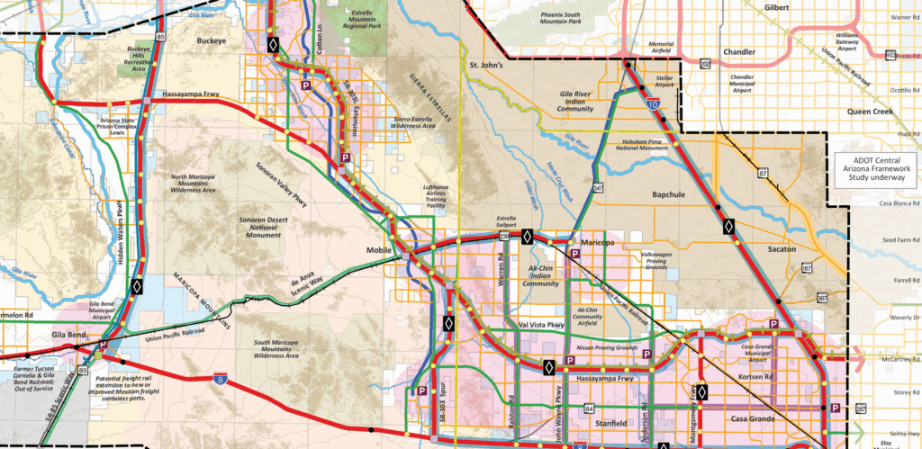
Think back to 2009. Barack Obama was the new guy in the Oval Office. Captain “Sully” Sullenberger landed a crippled jet on the Hudson River. Taylor Swift was only two albums in, and still country. That’s also when the Maricopa Association of Governments sketched a sweeping future for the open desert between Interstates 8 and 10 — a study area larger than Delaware that included Maricopa, Thunderbird Farms, Hidden Valley, Stanfield, Mobile, Casa Grande, Buckeye and Gila Bend, plus the Ak-Chin and Gila River Indian Communities.
Back then the whole area held roughly 90,000 people; MAG (correctly) projected about 450,000 by 2030 and nearly 2.5 million after 2050, with more than a million jobs at full build-out.
MAG didn’t create the Hidden Valley Roadway Framework Study in isolation. The process included development forums at Central Arizona College, focus groups on freight, environmental and government issues, and public workshops in Maricopa, Casa Grande and Mobile.
Sixteen years later, with 2030 just around the corner, here are six of the study’s most ambitious “what ifs.”
![This map shows the study boundaries of the I-8 & I-10 Hidden Valley Roadway Framework Study from 2009. [Maricopa Association of Governments]](https://inmaricopa.com/wp-content/uploads/2025/10/Screenshot-2025-09-10-140717.png)
1. Arizona parkways
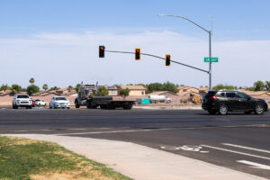
Instead of building costly freeways everywhere, MAG proposed “Arizona parkways” — one of three high-capacity road designations designed to carry nearly twice the traffic of a normal byway at a fraction of the cost. Plans called for six to eight lanes, wide medians and U-turn crossovers instead of left turns. Warren Road, John Wayne Parkway and Anderson Road were top candidates for upgrades.
2. HOV lanes everywhere
MAG assumed that future highways would all include at least six general-purpose lanes plus two HOV lanes, one in each direction. That meant I-10, I-8, State Route 238, the proposed Hassayampa Freeway (Interstate 11), a Montgomery Road Freeway and even a Loop 303 spur would have all carried lanes marked with the familiar white diamonds.
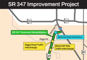
3. Hassayampa Freeway and Interstate 11
The longest stretch of highway on the ’09 map was the Hassayampa Freeway, a north–south corridor through Hidden Valley, Thunderbird Farms and Mobile. It was later folded into early proposals for Interstate 11, envisioned as a link from Tucson to Las Vegas. In 2022, InMaricopa reported groundbreaking was at least a decade away; as recently as this spring, what little efforts state lawmakers made to fund studies for the interstate were stricken from proposed legislation.
4. Commuter rail connections
Rail was supposed to be part of the picture. MAG floated a commuter line along State Route 347 connecting Maricopa to Tempe and Phoenix, and a Phoenix–Tucson intercity line with a stop in Maricopa. One concept even looped commuter rail around the southern edge of the Gila River Indian Community. The estimated price tag for rail in the study area alone: $1.3 billion in 2009 dollars. Now, Arizona is moving forward on a Buckeye-to-Tucson passenger rail corridor — but instead of passing through Maricopa, the proposed route swings east through Eloy and Queen Creek.
5. Parkway Bus Transit Corridors
The plan also envisioned bus rapid transit lines along major corridors like SR 347, Warren and Anderson Roads, paired with park-and-ride lots to connect commuters to Phoenix and Casa Grande.
6. Loop 303 spur linking Hidden, West Valleys
One of the most surprising proposals was a spur of Loop 303 running south from I-10 through Mobile to I-8. Depending on the alternative, it would have been a six-lane parkway or a full freeway, tying Hidden Valley directly into the West Valley freeway network.
What happened?
MAG officials now describe the 2009 framework as a long-range vision, not a funded program. “This a really old study that wasn’t really fiscally constrained or tied to any of current planning work,” said Transportation Planning Manager Arminta Syed. Spokesperson Jeff Sabato added, “Since the study is roughly 16 years old and isn’t tied to any of our current planning work, we do not have much to provide.”
However, one element from the era’s transportation aspirations gained real-world traction: the Sonoran Desert Parkway, part of the so-called East–West Corridor. The first segment opened two years ago, connecting Porter Road and the MCG to John Wayne Parkway near the Harrah’s casino, complete with wide lanes, lighting, landscaping and a new bridge over the Santa Rosa Wash.
So the Hidden Valley plan lives on as a time capsule. But with growth bearing down on SR 347 and new rooftops stretching toward Stanfield, the questions it tried to answer are still very much in front of us.

![A trio of campaign signs sit on the southeastern corner of John Wayne Parkway and Bowlin Road on May 21, 2026. [Monica D. Spencer]](https://inmaricopa.com/wp-content/uploads/2026/05/20260521-spencer-campaign-signs-2-300x200.jpg)