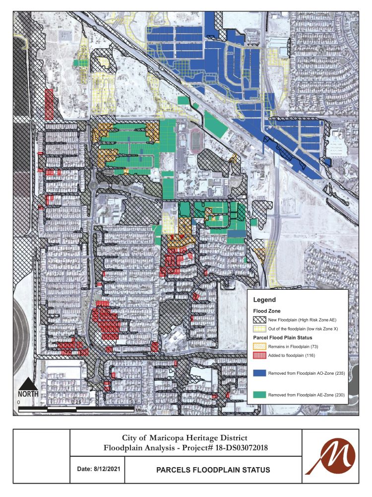
The Federal Emergency Management Agency (FEMA) has issued a Letter of Map Revision (LOMR) that redefines the boundaries of the Heritage District floodplain. Hundreds of properties, most of which are in Maricopa Meadows, are being removed from the floodplain as a result.
And in a move of no small consequence, more than 100 others are being reclassified as in the floodplain.
The moves carry significant weight, according to Mayor Christian Price.
“In the end, we removed 528 parcels from the floodplain,” Price said. “Some were in Maricopa Meadows and some in the Heritage District. It’s a way of saying that some of the things upstream have changed with what the county has done and other flood prevention measures that have been taken, so this is no longer the Maricopa that flooded in ‘92 and ‘93.”
Price said there will be tangible benefits for those whose homes are moved out of the floodplain as they will no longer be required by mortgage companies to purchase flood insurance. He added that as a precaution, they may want to continue to do so as they still are close to the floodplain.
City Engineer Eduardo Raudales said the city is in the process of notifying the affected residents and property owners.
“All residents that have been impacted by a change on their flood risk are being notified,” he said. City manager Rick Horst said notifications likely should be received by residents this week.
Raudales said once the public has been notified, there will be a 30-day comment period and an appeal period of up to 90 days before the new mapping can become effective. He said the city expects the revisions to become official before the end of the year.
In its Aug. 12 study, FEMA re-evaluated the floodplain at the city’s request to determine whether thousands of parcels would remain in, be removed from, or be added to the designated floodplain. The study fully removed 465 occupied and 63 vacant parcels from the floodplain. However, 116 parcels were added, leaving a net gain of 412 parcels removed.

Homes that carry a mortgage and lie within a designated floodplain are required to have flood insurance. It can be purchased from the National Flood Insurance Program (NFIP) or from a private insurer. The NFIP program is the primary provider of residential flood insurance in the U.S., covering more than 5 million homes and businesses, mainly in flood-prone coastal regions.
Raudales said the letters sent to those property owners who may need flood insurance include their risk category and a frequently-asked question and answer page to guide them through the process of identifying the need of an elevation certificate and/or a flood insurance. For those non-commercial property owners who do not possess an elevation certificate on file, the city has options to get one at a reduced cost.
The results of the survey were as follows:
- 5,527 parcels were checked
- 4,810 parcels will remain out of the floodplain with no change in status
- 465 occupied parcels were fully removed from the floodplain
- 63 vacant parcels were fully removed from the floodplain
- 116 parcels were added to the floodplain
- 73 parcels will remain in the floodplain with no change in status
The study was funded by the federal government through Community Development Block Grants.
According to Price, the city’s economic development team should also see a benefit from the redrawn map.
“It makes it much easier to plan and build in that area,” he said. “When companies do their due diligence, floodplain is one of the big things they look at – it’s a big, big, deal.”

![MHS G.O.A.T. a ‘rookie sleeper’ in NFL draft Arizona Wildcats wide receiver Jacob Cowing speaks to the press after a practice Aug. 11, 2023. [Bryan Mordt]](https://www.inmaricopa.com/wp-content/uploads/2024/04/cowing-overlay-3-218x150.png)


![Maricopa’s ‘TikTok Rizz Party,’ explained One of several flyers for a "TikTok rizz party" is taped to a door in the Maricopa Business Center along Honeycutt Road on April 23, 2024. [Monica D. Spencer]](https://www.inmaricopa.com/wp-content/uploads/2024/04/spencer-042324-tiktok-rizz-party-flyer-web-218x150.jpg)


![Alleged car thief released without charges Phoenix police stop a stolen vehicle on April 20, 2024. [Facebook]](https://www.inmaricopa.com/wp-content/uploads/2024/04/IMG_5040-218x150.jpg)

![MHS G.O.A.T. a ‘rookie sleeper’ in NFL draft Arizona Wildcats wide receiver Jacob Cowing speaks to the press after a practice Aug. 11, 2023. [Bryan Mordt]](https://www.inmaricopa.com/wp-content/uploads/2024/04/cowing-overlay-3-100x70.png)


