
It will be a short commute to high school for hundreds of future Maricopa students when the city’s latest subdivision, unanimously approved Monday evening, becomes reality.
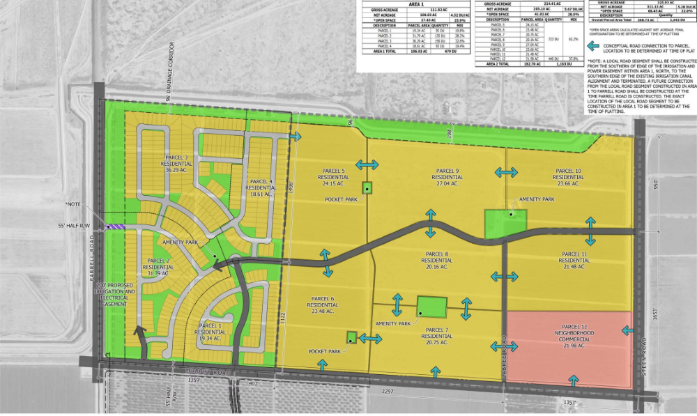
The 326-acre project, tentatively known as Murphy and Farrell, will lie just east of the city’s new Desert Sunrise High School. And it will provide plenty of its students, as the community will have 1,642 homes at full buildout, meaning the community will have more than 5,400 residents.
The commission approved a zoning change for the project, being developed by homebuilder DR Horton, from the existing general rural to planned area development. The land is at the southeastern corner of North Murphy and West Farrell roads. The project will now move forward for City Council approval, likely within the next month.
Initial plans for the property show 111 acres on two parcels slated for immediate development with 479 homes that will bring nearly 1,600 residents. The remaining 215 acres will be developed at a time to be determined. A 22-acre section at the southwestern corner of the site (the northwestern corner of Murphy and Steen Roads) is tabbed for future neighborhood commercial development.
City staff recommended approval of the project, stating in its report the project, “will permit ultimate development of the site that will optimize the city’s interests while allowing the applicant and future interests to develop the property to its highest and best use in conjunction with market conditions and market demand.
“Approval of this PAD will permit the applicant to bring further development opportunities to the underdeveloped southeast area of the city.”
According to pre-application documents submitted by DR Horton, “That proposed commercial area will provide for the goods and services necessary to support the planned residential community and other surrounding communities.”
The mixed-use phase also could include a high-density residential component.

The proposed modifications to the land-use standards include a 20 percent reduction of the minimum lot size standard, from 5,000 to 4,000 square feet; a corresponding reduction of the minimum lot width standard from 50 feet to 40 feet; and an increase to the permitted maximum lot coverage area of 55% for one-story residences and 50% for two-story residences to a maximum only limited by the district’s setback requirements, which are not proposed to be changed from the base standards.
Density of the fully-developed community will be 5.3 homes per acre – about 50 percent above the typical standard of 3.5 homes per acre for typical single-family communities. It will feature 68.5 acres open space, which represents 4.1 percent of the development.
According to city engineer Eduardo Raudales, it will take about two years before the site can be completed in terms of drainage and flood control.
Commissioner Bill Robertson had questions about the change in lot sizes and asked what the developer’s justification was for asking for smaller lot sizes.
“They are doing a very good job with their amenity package,” said city planner Derek Sheerer. “Unlike a lot of PADs we’ve seen, they have pocket parks and community parks, and they are mandating a rather extensive list of amenities that have to be provided. Where a lot of these other developments just put in a ramada and a barbecue, they have a strong list.”
Scheerer said that on the property’s east side a 50-foot-wide trail, which will be part of the city’s master-planned parks and trails system, is being incorporated into the community. He added that a planned on the north side will be developed with a 10-foot-wide concrete path and a four-foot soft pad to provide multiple uses, including walking and even equestrian.
He added that all the pocket parks would be amenitized and connected with the trails, and every residence will be within 880 feet of an amenitized park-like area.
“That’s the trade-off of the changes and adjustments to the base standards,” Scheerer said. “They are providing more with these parks and amenities.”