


The U.S. Department of Transportation has filed its findings for the Interstate 11 study corridor – a 2,000-foot-wide, 280-mile path stretching from Nogales to Wickenburg – and has recommended a route for the proposed freeway.
After more than five years of study, technical analysis and input from communities and stakeholders, the decision marks a major milestone as the final step in the Tier 1 Environmental Impact Statement process for this proposed highway corridor.
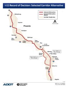
The corridor runs from Wickenburg into the Valley between Goodyear and Buckeye, then moves southeast using a portion of Arizona Highway 85 until it enters Pinal County and runs west of Maricopa and east of Hidden Valley. The route continues south of Maricopa, merging briefly with Interstate 8 before moving south toward Tucson. There are two potential routes through Tucson before the freeway merges with Interstate 19 for the final stretch to Nogales and the Mexican border.
North of Wickenburg, I-11 extends to Las Vegas and then on as yet undetermined route north to Canada.
Maricopa Mayor Christian Price said the route does not cross the current Maricopa city limits, but does run through the city’s planning area, which extends west to Goodyear and south to I-8. Price said the news is exciting but said people shouldn’t get too worked up about it just yet – whether they are in favor or oppose it.
“This is just the first step in a multi-step process,” Price said. “When they first start this process, it looks like someone threw spaghetti on a map. They talk about things like if the alignment goes here, it will be the most straight, the most direct, it will touch the least amount of tribal land and private land. Tier 1 dictates this area that’s 2,000 feet wide. That’s a long way – it’s a really wide area, almost half a mile wide.”
Scott Higginson, Executive Director of The Interstate 11 Coalition, said the announcement was a welcome decision.
“I’m pleased to share the good news with you that…we have an official, final EIS and route,” Higginson told supporters in an email obtained by InMaricopa. “This important event concludes over five years of work, study, public hearings and environmental evaluation of numerous proposed routes for Interstate 11 stretching from Wickenburg south to the Mexican border by ADOT and FHWA. This map (of the route from Wickenburg to the border) identifies the specific 2000-foot-wide corridor for Interstate 11.”
“This is terrific news,” Higginson continued. “We can now begin working on the next steps – Tier Two – in the process of determining the actual 200-300-foot-wide alignment within that larger corridor.”
The selected corridor alternative is a combination of new and existing roadways including US Highway 93; State Route 85; and Interstates 8, 10 and 19.
Price said that Tier 1 corridors typically cause plenty of consternation as people see what could lie in the potential path of the freeway. But he said no one should panic because Tier 2 will further refine the routing to minimize displacements or relocations and also takes the corridor down to 500 feet wide. That is when specific alignments come into play.
“Here’s an example,” Price said. “The Tier 1 alignment right now has it going over the top of Lucid Motors in Casa Grande. Now, everyone knows it’s not going over the top of Lucid; they just spent multi-millions of dollars to develop that facility. But it has to go close to it because they need the freeway access. That’s what Tier 2 is all about.”
He added that anyone concerned about the freeway changing things in Maricopa in the short term has nothing to worry about. “These things move very slowly,” he said. “Tier 1 took seven or eight years. Tier 2 takes another 10-15. They will build different sections at different times as they acquire the land, so we’re looking at construction in 25 years or more. It’s like, we are all driving on the 202 today, but if you told people 30 years ago there would be a freeway where the 202 is they would have thought you were crazy.
“This is a road that our kids and grandkids will drive on, not us,” he continued. “They will be the beneficiaries of someone having the foresight 30 years ago to know that this I-11 would be necessary. And another thing to remember is that when this is built initially, it will not be like the 101 or 202 is today. It will initially be a two-lane road. Everyone thinks it’s going to be like I-10 right away, but it will be built small and as traffic increases, they will continue to build it out. You’re talking about millions of dollars a mile, so they don’t want to build it before they have to.”
During the Tier 2 process that the route would be narrowed to a maximum 400-foot-wide highway alignment. Based on need and purpose, these segments would focus on smaller and shorter sections of I-11 and not the entire 280-mile corridor. Currently there are no plans or funding available to initiate these Tier 2 studies.
The proposed I-11 is envisioned as a multi-use corridor that would improve Arizona’s access to regional and international markets while opening up new opportunities for enhanced travel, mobility, trade, commerce, job growth and economic competitiveness. The concept of a high-capacity, high-priority north-south transportation facility that connects western U.S. markets to Canada and Mexico has been considered for more than 25 years.
Funding for the Tier 2 study may be available as part of the recently passed bipartisan infrastructure bill, which contains a provision creating a $17 billion fund states can draw upon for funding for pre-construction activities such as a Tier 2 studies.

![Maricopa Police Chief Mark Goodman speaks to Maricopa City Council while presenting his department's annual report on April 7, 2026. [Monica D. Spencer]](https://inmaricopa.com/wp-content/uploads/2026/05/GOV-Crime-Stats-by-Monica-D-Spencer-300x200.jpg)


![A photo of a custom-made Glacier Springs Water system, layered over a photo of person washing a cup in a sink. [Glacier Springs Water, Cotton Bro Studio]](https://inmaricopa.com/wp-content/uploads/2026/06/20260611-glacier-springs-water-300x169.jpg)
![William Senne, arrested June 2, 2026. [Pinal County Sheriff's Office]](https://inmaricopa.com/wp-content/uploads/2026/06/20260610-william-senne-arrest-300x170.jpg)

![Maricopa Police Chief Mark Goodman speaks to Maricopa City Council while presenting his department's annual report on April 7, 2026. [Monica D. Spencer]](https://inmaricopa.com/wp-content/uploads/2026/05/GOV-Crime-Stats-by-Monica-D-Spencer-150x150.jpg)