


It’s one of Maricopa’s best-kept secrets, even if it’s a massive half-million acres with three federally protected desert wilderness areas.
Sonoran Desert National Monument is a huge but lesser-known attraction in the 85139 ZIP code, with 26 miles of hiking trails in wilderness settings.
Even the federally designated park’s visitor center, which is in the city of Maricopa, gets few inquiries about the monument from hikers exploring the area, said people who work there.
“We just get it now and then,” said Dorothy Charles, who oversees the archives at the visitor center, 44200 W. Maricopa-Casa Grande Highway. “It’s hit and miss.”
Charles would like to see more of her Maricopa neighbors take advantage of the wilderness adventure in their backyard.
Making a monument
President Bill Clinton proclaimed the vast desert land a national monument nearly a quarter-century ago. Designating the national monument was one of Clinton’s final acts at the end of his second term in 2001.
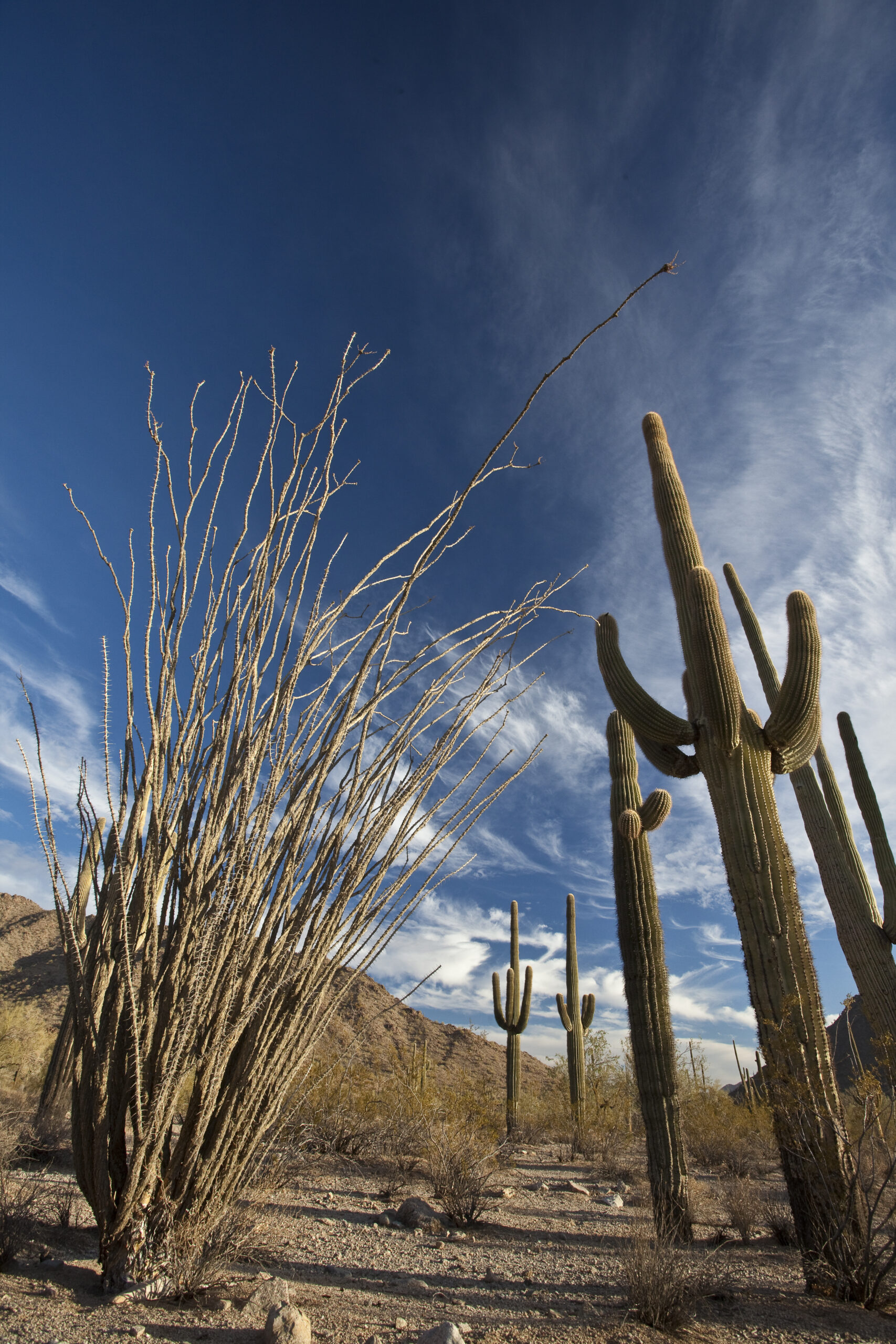
The monument is a place you’ll find untamed and undisturbed green prickly towers of ancient saguaro cactus, probably the single most iconic symbol of Arizona. Many of them can be seen near the edges of deeply contrasting cottonfields at Hidden Valley Road near the Box Canyon Shooting Range, west of Maricopa.
Charles recommends seeing the monument when the saguaros are blooming in April.
The monument extends from south of Interstate 8 to the northern edge of the Gila River Indian Community, touching the southern outskirts of Buckeye. Though the U.S. Bureau of Land Management says park HQ is in Maricopa.
“It’s not a national park because it was established by presidential proclamation,” said Chris Wonderly, public affairs specialist for the BLM District Office in Phoenix.
Only the U.S. Congress can designate a national park or wilderness areas, Wonderly said.
Maricopa access to the monument is as close as State Route 238, just 8 miles west of the city.

Trail blazing
Because of its federal status, the monument is less protected than a national park, though it is still primarily accessible only to hikers, trail cyclists and horseback riders. Visitors on foot, two wheels or saddle can camp for free inside the monument. But if you’re looking for a place to ride an offroad vehicle in the wilderness, you might as well go elsewhere, one Hidden Valley offroad advocate said.
“Riding UTVs and ATVs out there is banned,” said Sonny Hawkins, administrator for the Hidden Valley UTV group on Facebook. “You can’t go off trail without being a recipient of a huge ticket if they catch you.”
Besides the monument’s extensive desert flora and trails system, visitors find dramatic views of the Maricopa, Sand Tank and Table Top mountain ranges, as well as the Booth and White hills, all separated by wide valleys.
Visits to the Sand Tank Mountains, south of Interstate 8, require a Barry M. Goldwater Range permit. The permit is free but requires the recipient to watch a 13-minute safety video. Permits are valid for one year and are only available online.
Early Indigenous peoples, Spanish explorers, homesteaders and miners crossed the monument’s central corridor near Hidden Valley. The monument features three congressionally designated wilderness areas, archaeological and historic sites, and remnants of several important historic foot routes, including the Juan Baptista de Anza Trail. The Anza Trail weaves through the Sonoran Desert for 1,200 miles, from Sonora, Mexico, to San Francisco.
The three wilderness areas are only accessible by foot.
Arroyo Seco, or Dry Stream, an Anza Trail historic campsite, is within the monument. The Anza expedition camped there Nov. 7, 1775.
On the west side of the monument, there’s an Anza Trail interpretive sign marking a trailhead along Maricopa Road.
SR 238 and Maricopa Road present access to the North Maricopa Mountains and the historic Butterfield Overland Stage Route, another congressionally designated feature of the national monument that runs parallel to the Mormon Battalion and Gila Trails.
Hidden in plain sight
Regardless of its federal status and size, the national monument is not on most Maricopans’ radar.
More than half of 215 readers surveyed in an InMaricopa poll in January said: “I’ve never heard of it.”
One-fifth of the readers said they had heard of the monument but never visited it.
SR 238 leads directly into the belly of the monument with periodic roadside access to its trail system. A network of rough dirt roads weaves through the monument, which touches areas of private and state trust lands.
The monument is a place to see extensive forests of the giant armed cactus that rival populations in the Saguaro National Park near Tucson.
Although no permit is required to camp inside the monument, RV travelers should not stray too far into the low brush to avoid the risk of getting stuck in a rocky arroyo or sandy, dry riverbed.
The only place visitors can’t camp is in the wilderness areas.
Not as serene as it seems
The southern part of the monument is a known corridor for drug and human smugglers. BLM officials said monument visitors in that area should be alert for illegal activities and law enforcement operations.
BLM last year drastically downsized an area open to recreational target shooting within the Sonoran Desert National Monument.
The agency, after an extensive study and public comments, pared down target shooting from 435,700 acres down to just 5,295 acres of the monument, about 1% of its landmass. The BLM’s June decision banned shooting on the monument’s remaining 480,496 acres.
BLM officials said target shooting is allowed on other bureau-managed lands in and around the Phoenix area, but not within the monument. About 93% of the 12.1 million acres of BLM-managed lands in Arizona remain open to dispersed recreational shooting.
During BLM’s review period, critics argued target shooting threatened cultural and natural resources the monument was designated to protect. Opponents contended shooting had damaged valued objects inside the monument, such as saguaro cacti and Native American petroglyphs.
“The BLM worked to find a safe balance between various recreational uses of public lands while protecting objects of historic or scientific interest in the national monument,” said Phoenix District Manager Leon Thomas.
Know before you go
The Sonoran Desert National Monument’s wilderness areas offer many opportunities to explore and discover the secrets of the Sonoran Desert. The North Maricopa Mountains Wilderness, the South Maricopa Mountains Wilderness and the Table Top Wilderness areas allow for solitude and unconfined recreation, BLM officials said.
The North Maricopa Mountains Wilderness has two hiking and equestrian trails: the 9-mile Margie’s Cove Trail and the 6-mile Brittlebush Trail. The Table Top Wilderness also has two hiking and equestrian trails: the 7-mile Lava Flow Trail and the 3-mile Table Top Trail.
A four-wheel-drive route follows the trail corridor for about 10 miles through the national monument.
Offroad vehicle advocate Sonny Hawkins, who lives in Hidden Valley, said the trail corridor is much too narrow for more than one offroad vehicle.
The area north of SR 238 and just west of Maricopa is temporarily allowed for hiking and equestrian use only to allow for natural reclamation of resource damage caused by vehicular overuse.
Visitors are allowed to park off SR 238 at the access points and hike in from there.
The area north of 238 and south of the North Maricopa Mountains Wilderness is closed to vehicle entry without written permission. Visitors can request a letter of agreement to access these areas by contacting the Lower Sonoran Field Office.
Construction has closed Roads 8002b, 8002c and 8002 from SR 238 to BLM’s Road 8003.
From Maricopa to the southern part of the national monument, take John Wayne Parkway south to Interstate 8 via State Route 84. Proceed west on I-8 to Vekol Road and turn south. For information about other access routes, contact BLM’s Phoenix field office at 602-867-5400.
Once access is established, visitors can find hiking, backpacking, stargazing, camping, hunting, motor touring, sightseeing, photography and horseback-riding opportunities.
Visitors can hike or ride horseback virtually anywhere in the Sonoran Desert National Monument. The four designated wilderness trails offer a unique opportunity to explore the backcountry.
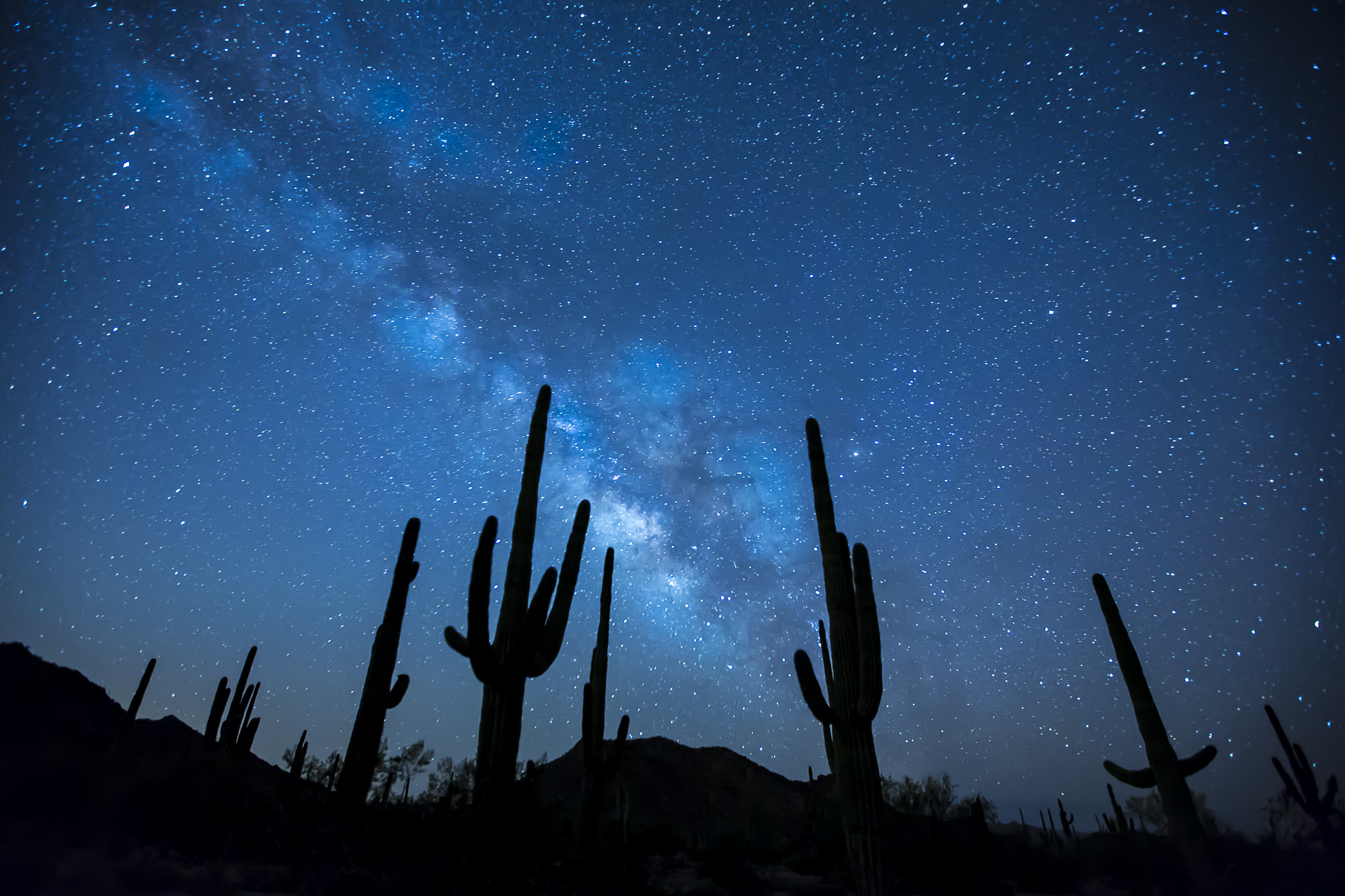
Dispersed camping and picnicking are allowed throughout the monument unless otherwise posted. Desert camping allows visitors to take short scenic hikes and survey unique vegetation or the starry skies at night.
Two small campgrounds at Margie’s Cove West and Table Top trailheads offer a restroom and three small campsites with a picnic table and grill. No water or hookups are available. Sites are first-come, first-served. The restrooms are wheelchair accessible, but there are no other accessible facilities at the monument.
More than 460 miles of posted roads are available for backcountry, offroad vehicles and mountain bikes outside the wilderness areas.
The monument is home to a variety of wildlife, including desert bighorn sheep, mountain lions, mule deer and javelina. Many small birds and reptiles thrive year-round, including bats, owls, rattlesnakes and the Sonoran Desert tortoise. If you’re lucky, you might even spot the Arizona state mammal, the ringtail.
Collecting, removing or damaging natural and cultural resources, such as artifacts, live or dead plants and rocks, are prohibited.
BLM officials urge visitors to “know before you go” to the monument by checking with the office for current conditions.
The monument is a remote area, and recreational opportunities are on primitive trails and access roads that are not maintained. No water or trash collection is provided.
Cellular phones do not work in many areas of the national monument, according to the BLM, but reception is strong near Hidden Valley. “There aren’t a lot of paved roads,” BLM spokesman Chris Wonderly said. “The monument is just a lot of wilderness.”
The monument’s elevation ranges from 1,000 to 4,400 feet, so summer can be rough on visitors.
Wonderly said the best time to enjoy the monument is from late October to mid-April when the weather is cooler. Monument visits during summer months are discouraged, with temperatures often above 110 degrees. Otherwise, it is recommended that visitors pack in plenty of water, sunscreen, sunglasses and large-brimmed hats.
The desert sun stirs up rattlesnakes and other reptiles as early as this month, BLM officials warn, so be on the lookout.


![Western Pinal Justice of the Peace Patricia Glover speaks during a City of Maricopa Republican Club on May 23, 2026. [Monica D. Spencer]](https://inmaricopa.com/wp-content/uploads/2026/05/20260529-spencer-teeple-republican-club-1-4-300x200.jpg)