
The Maricopa City Council has approved funding to acquire a right of way along Farrell Road for the long-awaited East-West transportation corridor.
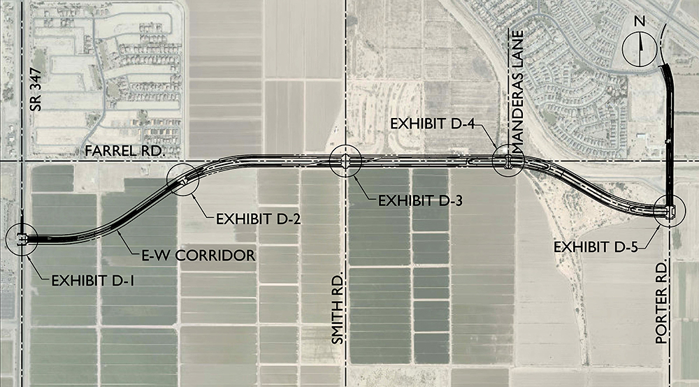
The proposed parkway will eventually connect State Route 347 and Interstate 10, north of Casa Grande, potentially alleviating traffic congestion on SR347 between Maricopa and I-10 in Chandler as a second route to the Valley. It is proposed as a four-lane thoroughfare, with potential expansion to six lanes if warranted in the future.
The 26.5-acre right of way lies just south of Farrell between SR347 and Porter. It was purchased from Property Reserve Arizona, LLC (PRA), which is held by Fulton Homes, for $1.06 million.
The deal is the second amendment to the original development agreement between the city and PRA signed in 2008 and first amended in 2014. The agreement allows for the development of 1,996 acres on the south side of Farrell Road known as the Avalea Property.
As part of its transportation strategy, the city has identified Farrell Road as the recommended alignment for the initial, westernmost portion of the Corridor. The city decided to build on the south side of Farrell because a large parcel of land on the north side is owned by the state.
“The process of getting land away from them (the state) is virtually impossible, or at least it takes a long time to get it,” Horst said. “So that’s the reason the landowners to the south of us agreed to work with us, so we could just move it (the corridor route) further south.”
Moving the parkway to the south required the city’s acquisition of the 26.5 acres from PRA.
PRA also will convey a 1.64-acre triangular parcel on the southeast corner of SR347 and Farrell Road, north of the parkway alignment which move south of Farrell and terminate at the entrance way to the Harrah’s Ak-Chin Hotel and Casino. That property will be paid for through a credit to the developer toward planning and development, engineering and/or building safety application and review fees totaling $65,600.
According to City Manager Rick Horst, the small triangle of land is necessary for several reasons.
First, a Maricopa Stanfield Irrigation District line runs through the area, and it must be accommodated to ensure the city doesn’t have to completely rebuild it later.
Secondly, the city must be able to line up intersections at a 90-degree angle, so the roadway has to shift south to achieve that alignment.
“It’s all about saving time and saving money,” Horst said. “That’s the big reason it moves a little bit south there.”
Eventually, five access points to the parkway with traffic signals will be designed, constructed and funded by the city. At least one, at SR347 opposite the Harrah’s entrance, will be part of initial construction. One of the access points will also be an entry from the parkway into the Santa Rosa Springs development via Manderas Lane.
If the corridor and access points are not built by Sept. 26, 2028, the land described in the deal will convey back to PRA.