

We’ve reported a few fatal traffic crashes in Maricopa already this year. But how do fatal crashes in Maricopa stack up against the rest of the state?
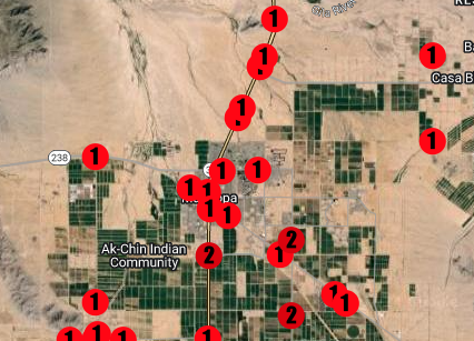
Below is a map of fatal crashes in the Maricopa area between 2019 and 2022. Arizona Department of Transportation has not yet released 2023 crash data.
Click on the “maximize” button in the top right to view crashes by the year. The numbers on each pin represent the number of deaths.
InMaricopa included pins for crashes in Hidden Valley and Thunderbird Farms, on Interstate 10 between Loop 202 and Casa Blanca Road, State Route 238 west to Maricopa Mountains, and Interstate 8 between South Vekol Valley Road and Montgomery Road.
Below is a map of fatal crashes in the state from 2019 to 2022.
Editor’s note: This data lacks 91 fatal crashes during those four years as ADOT was unable to provide exact location information.