

The City of Maricopa this week released a feasibility study of the first phase of the so-called Green Road loop, proposed to relieve the gnarl of future traffic by reducing the number of vehicles on State Route 347.
In the report, while creating new opportunities for economic development Phoenix consultant firm Wilson & Company states that the new road would “support growing travel demands associated with future development of the area, and employment for the Gila River Indian Community.”
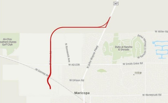
The first phase would be routed on the city’s west side along the Green Road alignment, beginning at McDavid Road, following Green Road, crossing the Union Pacific Railroad and continue north past Smith Enke Road. It would then turn east and cross through the Gila River Indian Community until it connects with SR 347, north of the city.
By providing an alternative road that would attract vehicles away from John Wayne Parkway, the new road would create access to Gila River Indian Community adjacent to the SR 347 corridor, creating future land use and development to generate revenue and employment for the community.
The report predicts that about 11,240 vehicles will use the proposed Green Road route each day, including traveler and commercial trucks.
The consultants recommend two lanes in each direction be constructed “at full build-out.” Other amenities such as sidewalks, lighting and landscaping are recommended, and the roads would be separated by a landscaped median.
“The 11,000-plus vehicles that are estimated to travel the loop each day represent potential patrons that may be attracted to new businesses along the loop,” Wilson consultants said.
Commercial use could include drug stores, banks, fine-dining and fast-food restaurants, coffee shops and drive-throughs, gas stations and convenience stores.


![Western Pinal Justice of the Peace Patricia Glover speaks during a City of Maricopa Republican Club on May 23, 2026. [Monica D. Spencer]](https://inmaricopa.com/wp-content/uploads/2026/05/20260529-spencer-teeple-republican-club-1-4-300x200.jpg)