

The legendary naturalist John Muir was an early advocate for preserving the wilderness of America.
Called the “Father of our National Parks,” he was passionate both about nature and inspiring people to get out into the wild.
Poll: Do you support the plan for Palo Verde Regional Park?
“Everybody needs beauty … places to play in and pray in where nature may heal and cheer and give strength to the body and soul alike,” said Muir, who lived in (and loved) the Arizona high desert for a short period of his life.
Parks and recreation provide three values that make them essential services to communities — economic value, health and environmental benefits, and social importance — according to the National Recreation and Park Association.
Maricopa’s government and community leaders understood these benefits well when the City Council greenlighted Copper Sky regional park and recreation center in 2008. Voters agreed, approving $53 million in bonds to build the 93-acre park, which has been the jewel of city facilities since opening in 2014.
The Bureau of Land Management, whose mission is to “sustain the health, diversity and productivity of public lands for the use and enjoyment of present and future generations,” seeks to fulfill that promise with the construction of the Box Canyon Shooting Range at the base of the Palo Verde Mountains, west of Maricopa.
Now, Pinal County, whose motto is “wide open opportunities,” is working to build its own recreational jewel in the desert in the same area. The sprawling, nearly 23,000-acre Palo Verde Regional Park would stretch from State Route 238 in the north to Interstate 8 in the south. (By comparison, the city of Maricopa today numbers about 27,000 acres.)
“The park was identified all the way back in 2007,” said Kent Taylor, who has been guiding the project since becoming county director of open space and trails in 2013. “The need has been there for some time.”
Once built, the park would offer miles of interconnected trails and places for camping and hiking, riding horses and off-highway vehicles, and, perhaps, disc golf, BMX biking and ziplining.
It will likely take decades to fully realize the county’s vision, Taylor said.
“A regional park such as the Palo Verde Regional Park is going to be a great resource for folks to use for their recreational needs,” said Jeffrey McClure, chairman of the Pinal County Supervisors, who represents District 4 (and Maricopa, till district realignment in June.) “As we continue to grow as a county, and as the city of Maricopa continues to grow, our wilderness areas will continue to shrink. We must continue to attempt to preserve as much of this type of land as possible for the present and future generations.”
A growing need
Pinal County and the city of Maricopa are growing rapidly.
The county’s population, about 380,000 in 2010, has grown to about 510,000, according to estimates, an increase of nearly 35%. Maricopa is the largest city in the county, with about 63,000 residents, up from about 43,500 in 2010. Pinal’s population will reach 732,000 by 2025 and 1.3 million by 2050, according to Arizona Department of Commerce estimates. Maricopa will boast 121,600 of those residents according to the City.
Population was already exploding in 2007, when Pinal County planned for the construction of seven regional parks. Working toward a goal of 7,236 park acres by 2025, the county hopes to open its first regional park, Peralta, east of Gold Canyon, in January 2023.
Rapidly growing communities bring increased demand for enhanced recreation opportunities by Pinal residents and visitors traveling through the area, including from metro Phoenix, said Chris Wonderly, BLM public affairs specialist.
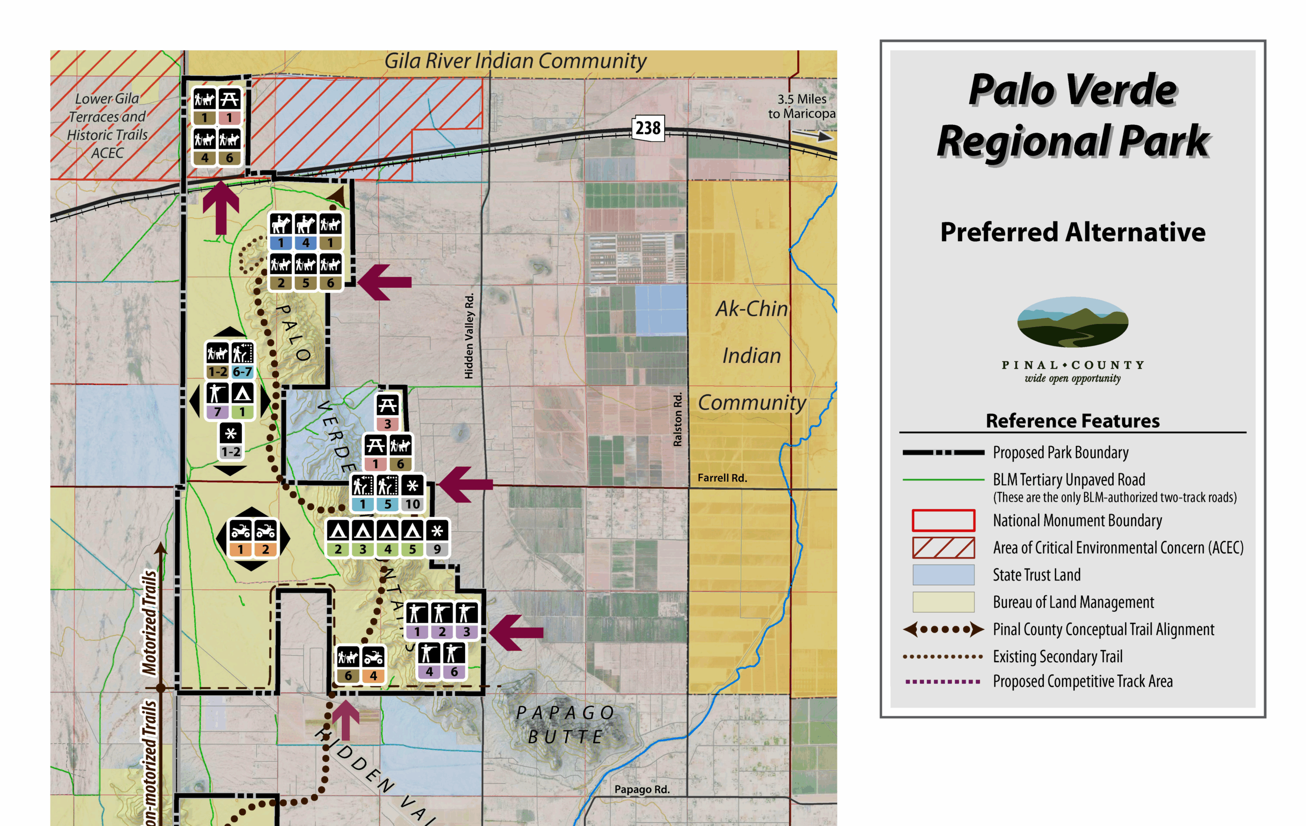
The first phase of Palo Verde Regional Park will comprise 6,000 acres south of SR 238. After completing an environmental assessment, Pinal County is seeking a 25-year, no-cost lease from BLM under the Recreation and Public Purposes Act for three parcels — nearly 500 of those acres — to develop amenities. The County also seeks a right of way for a non-motorized trail system to link the three parcels.
Calling himself a “big proponent” of the project, Maricopa Mayor Christian Price said the plan protects, preserves and improves the land.
“Having this land in contract with Pinal County is good for this area,” he said. “The reality is federal land can be shut down by the government. That can’t happen with a contract with the county.”
The park would have economic benefit, too, said Taylor, suggesting that as one reason for support from the City of Maricopa, which acknowledges the future regional park in its General Plan.
Anthony Smith, a former member of the Pinal County Board of Supervisors and a past mayor of Maricopa, agreed.
“As county supervisor, I strongly promoted the idea of the Palo Verde Regional Park because recreation and tourism are very important ingredients for achieving economic development and promoting healthy communities for our citizens in and near Maricopa and Hidden Valley,” said Smith. He added that such amenities are important when competing for economic development with other states in the Southwest.
“If you have a regional park that is similar to Phoenix’s South Mountain Regional Park, three times its size and nearly on your doorstep, it can be another advantage when businesses are considering relocating to your community.”
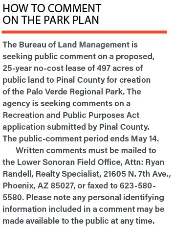
With the preliminary design for Phase I development completed, County staff are working on the final approvals with BLM to acquire the lease. Meanwhile, BLM is seeking public comment on the county’s application through May 15. (see box.) If the lease is approved, the County will begin work on the final design and construction documents needed for park development. That process is expected to start 1-2 years after issuance of a lease and right-of-way grant.
A ’pretty outstanding’ setting
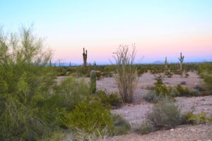
Local residents already play in the distinctive Palo Verde Mountains, which rise 2,121 feet from the Sonoran Desert floor at its narrow peak and take their name from the plentiful Palo Verde trees in the region.
With its steep sides and mostly continuous crest, the small range is a centerpiece of more than 1.4 million acres of mountain ranges, alluvial plains and riparian areas managed by BLM in its Lower Sonoran Decision Area.
In a prime location, the park would connect the Table Top Wilderness area to the south and the Sonoran Desert National Monument to the southwest and several planned regional trails.
The area is already used for recreation by the public, despite a lack of BLM oversight or facilities. Popular activities include hiking, horseback riding, wildlife observation and off-highway vehicle use.
The park would be adjacent to the Box Canyon Recreation Area, 1,100 acres just west of Hidden Valley Road that will include the shooting range. Shooters have frequented the area for years.

The shooting range in Box Canyon is being developed, at least in part, to discourage what BLM calls a “demonstrated misuse of public lands.”
Price also cited Box Canyon as an example where current recreation at the mountain range is a bit of a “free-for-all” and a “safety issue.” The range will offer more shooting opportunities in a safer atmosphere, he said.
With spectacular scenery, easy accessibility and proximity to other geographical features, the area is a great setting for a public park, Taylor said.
“In the park world, we talk about quality of life and adding to that quality of life,” he said. “The Sonoran Desert environment that this facility will reside in is pretty outstanding.”
Phase 1 plan
With full buildout likely decades away, the development of the northern portion of Palo Verde Regional Park would happen much sooner, perhaps within 3-4 years, Taylor said.
Phase 1 would include some 6,000 acres of land bordered by SR 238 to the north, West Fulcar Road to the south, Hidden Valley Road to the east and the Maricopa County line to the west. That section and a much larger one to the south will one day be bisected by Interstate 11, the proposed route of which runs across Hidden Valley to the west side of the mountains.
Roughly in the shape of a small “h,” Phase 1 would include three main recreation areas at McDavid, Farrell and Table Top roads. Most recreational users would enter the park at those three points.
The master plan calls for a loop driveway, parking and trailhead facility that accesses non-motorized trails at the end of West McDavid Road. The main entrance, at the end of West Farrell Road, would feature another trailhead, a developed campground, a sunken archery range, group camping area and administrative facilities. Another trailhead access point for off-highway vehicles would be located on the west side of the parcel at the end of Table Top Road (a little further west than it shows in the original master plan).
Recreational opportunities could include hiking and horseback riding trails, bird-watching areas, a nature center, picnic areas and playgrounds, and places for shooting sports, geocaching, rock climbing and an off-leash dog enclosure.
More than 26 miles of trails are planned in this first phase, with about 3.7 miles within the county-developed sites.
“The trails are planned and designed in a sustainable way to blend in with the environment,” Taylor said. “They don’t disturb cultural or biological resources. The camping is in a developed site where there’s restrooms and water and electricity, so we don’t have folks just driving unobstructed through virgin desert. When we go in and develop the trailhead, we’re not developing virgin desert. We’re developing places that are already physically disturbed.”
Not all amenities would necessarily be available from the start; some would likely be developed over time.
New infrastructure would include restrooms, water stations, trailheads, entry stations, host sites, internal park roadways, equestrian staging, off-highway vehicle staging and a maintenance yard.
At the McDavid and Farrell facilities, potable water and electric service would be available either with initial construction or future site improvements for use at restrooms and campsites. Restrooms and host sites would be designed with septic systems and leach fields, though sewer lines may be extended to this site in the future. At the Table Top Road area, restrooms would feature waterless vault toilets and host sites would have electricity powered by solar shade canopies.
Taylor said staff will likely be on site 365 days a year.
“We’re just trying to develop the northern portion,” Taylor said. “I would think the southern part would develop separately and there might be trail connection that provides connectivity between the north and the south.”
That link could be a grade-separated crossing or a trail network that’s worked into the existing road network.
The plan has garnered much support from residents and government leaders — but not everyone thinks it’s a good idea.
Supporters and detractors
Three county-led public meetings/open houses and two web-based surveys since December 2015 have sought public review and comment on the project. Those meetings, including one at Copper Sky, drew a total of 273 residents.
For the most part, public comments were minimal and generally supportive of the project, according to Taylor, who acknowledges that as early as 2016, there were detractors, too.
Members of a private Facebook group, Citizens Against Palo Verde Regional Park, say they already use the mountains and surrounding area for recreation — and have for many years.
In a statement to InMaricopa, the group said:
“Our stance remains the same. This area is already public lands, federal lands and many utilize it for numerous outdoor activities. This proposed action is adding further restrictions on the users and additional costs to use.”
“There is absolutely no reason they need to charge us for land use that we have access to and used for many, many years. The area is NOT blight, it is NOT destroyed; the areas where trash are dumped are easily accessed areas and most are private property … It really is a ridiculous thing to do.”
The group also contends county parks inevitably lead to tax hikes.
“Taxes must increase as user fees across the board at county parks do NOT sustain the parks. They are ALL supplemented by taxation … To us, this makes no sense. None of it.”
Taylor said user fees are likely for some amenities and activities, and that county supervisors will determine fees once specific amenities are set. He also acknowledged that user fees typically do not cover full operational costs, noting supervisors would decide how to make up the shortfall.
June Staruch, a Hidden Valley resident who moved to the area 22 years ago, said she has issues — many of them, in fact — with the park.
“I am not happy at all,” she said, ticking off her concerns.
A stargazer, she said her heavenly view is already compromised by light from Maricopa and Copper Sky.
“And now we are going to have a park with lights?” she said. “No! I don’t care if it is two miles away, six miles away, 10 miles away, it destroys the night sky that we love.”
She added the park will bring more noise and dust from off-road vehicles and she fears wildfires starting in the campgrounds.
“Thunderbird Fire Department has their hands full as it is,” Staruch said. “In two months, we have had three really bad fires. Two houses within two miles of me burned to the ground and the (Maricopa Pantry) food bank was destroyed by fire. We do not have the resources to fight fires, and if we have campgrounds, we are going to have fires. That puts everyone in Hidden Valley at risk. This is a nightmare waiting to happen.”
For his part, Taylor said he is “always willing to talk to folks” who want to share their opinions about the park plan in a professional and productive manner.
Price said he understands the city, and perhaps its outlying rural areas even more so, are changing. Some people will resist that change, he said.
Taylor thanked Maricopa government leaders for their support.
“I’d be remiss to leave out the City of Maricopa, which has been a staunch supporter of this project since Day One and continues to be,” he said. “They realize this is going to be a tremendous amenity (that) will help them in their efforts to build their community.”
Price agreed, saying opening the land for enhanced recreational opportunities is good for his city.
“Pinal County can spend tax dollars there to improve the area and that benefits Maricopa,” said Price, noting the park would sit within the city’s tourism-focused adventure corridor along SR 238.
“Isn’t that the purpose of public lands? For people to enjoy them.”
This story was first published in the May edition of InMaricopa magazine.


![Western Pinal Justice of the Peace Patricia Glover speaks during a City of Maricopa Republican Club on May 23, 2026. [Monica D. Spencer]](https://inmaricopa.com/wp-content/uploads/2026/05/20260529-spencer-teeple-republican-club-1-4-300x200.jpg)